


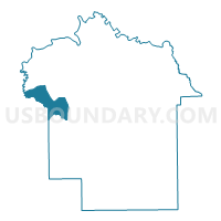
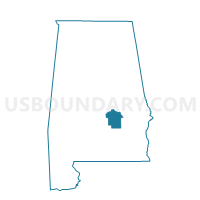
2L First Southern Baptist Church Voting District, Montgomery County, Alabama
About
Outline

Summary
| Unique Area Identifier | 522675 |
| Name | 2L First Southern Baptist Church Voting District |
| County | Montgomery County |
| State | Alabama |
| Area (square miles) | 21.38 |
| Land Area (square miles) | 20.90 |
| Water Area (square miles) | 0.48 |
| % of Land Area | 97.76 |
| % of Water Area | 2.24 |
| Latitude of the Internal Point | 32.25364940 |
| Longtitude of the Internal Point | -86.40908170 |
Maps

Graphs
Select a template below for downloading or customizing gragh for 2L First Southern Baptist Church Voting District, Montgomery County, Alabama


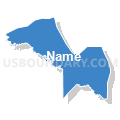


Neighbors
Neighoring Voting District (by Name) Neighboring Voting District on the Map
- 2F Fire Station No. 14 Voting District, Montgomery County, AL
- 2I Southlawn Elementary School Voting District, Montgomery County, AL
- 2K Catoma School Voting District, Montgomery County, AL
- 2M Pintala Volunteer Fire Dept Voting District, Montgomery County, AL
- Burkville Volunteer Fire Dept., Lowndes County, AL
- New Pleasant Valley Church, Lowndes County, AL
Top 10 Neighboring County Subdivision (by Population) Neighboring County Subdivision on the Map
- Montgomery CCD, Montgomery County, AL (189,183)
- Hope Hull CCD, Montgomery County, AL (8,627)
- Hayneville CCD, Lowndes County, AL (3,620)
Top 10 Neighboring Place (by Population) Neighboring Place on the Map
Top 10 Neighboring Unified School District (by Population) Neighboring Unified School District on the Map
Top 10 Neighboring State Legislative District Lower Chamber (by Population) Neighboring State Legislative District Lower Chamber on the Map
- State House District 76, AL (44,894)
- State House District 69, AL (37,572)
- State House District 78, AL (30,880)
Top 10 Neighboring State Legislative District Upper Chamber (by Population) Neighboring State Legislative District Upper Chamber on the Map
Top 10 Neighboring 111th Congressional District (by Population) Neighboring 111th Congressional District on the Map
Top 10 Neighboring Census Tract (by Population) Neighboring Census Tract on the Map
- Census Tract 59.01, Montgomery County, AL (4,865)
- Census Tract 7808, Lowndes County, AL (3,620)
- Census Tract 60, Montgomery County, AL (3,611)
- Census Tract 61, Montgomery County, AL (2,243)